Amami archipelago
Overview of the Amami Islands
Location, Population and Administrative Structure of the Amami Islands
Location of the Amami Islands
The archipelago consists of several islands spread like steppingstones in the area of:
Latitude: 28° 32′ 44.00″ N and 27° 01′ 07.00″ N;
Longitude: 130° 02′ 07.00 E and 128° 23′ 43.00 E.
The nautical distance from Kagoshima City to Kikaijima island, an island at the northeastern end of the archipelago, is 377Km, and to Yoronjima island, the southern end of the Amami Islands, is 594km.
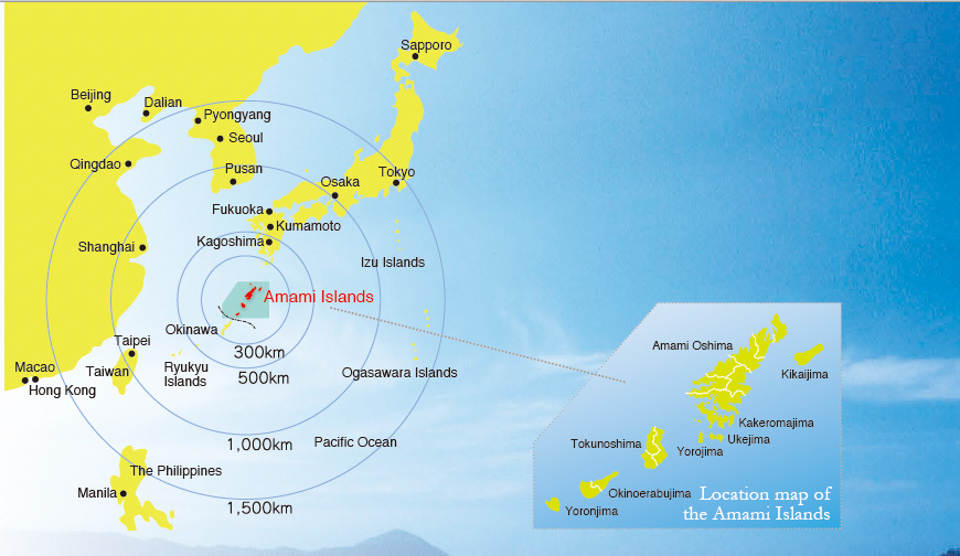
Location of the Amami Islands
Inhabited islands
Amami Oshima, Kakeromajima, Ukejima, Yorojima, Kikaijima, Tokuoshima, Okinoerabujima and Yoronjima (eight islands)
Total area coverage
1,231.11km2, of which Amami Oshima, the biggest island in the archipelago, occupies 712.35 km2.
Climate
Subtropical and oceanic climate.
With an annual average temperature at around 21°C, and average precipitation of 3,000mm, the climate of the archipelago is moderate and humid throughout the year. The area where the islands spread is also known as an area where typhoons frequently passes.
Total population
Its population reached its peak at 226,752 on 31 December 1949. However, it has experienced an outflow of the population since then. According to the 2020 preliminary report of national census, the total population was 106,033.
Administrative structure
At the time the islands were returned to Japan, after the occupation by the US after WWII, on 25 December 1953, the number of municipalities in the Amami archipelago were: one city, five towns and 14 villages. After going through several municipal mergers, currently, there are one city, nine towns and two villages.
A UNESCO’S World Natural Heritage Site
Formation of the Amami Archipelago
Rocks and soil that constitute the foundation of the Nansei islands, to which the Amami archipelago belongs, are originally the dirt deposited in the Pacific Ocean 100 million years ago (Shimanto group as noted in the stratigraphic terminology). This dirt accumulated and rose, over tens of million years, at the location where the Philippine Sea Plate sinks beneath the Eurasia Plate, forming the archetype of the Nansei islands. It is considered that creatures migrated from the continent to the newly formed land, still connected to the Eurasia continent back then. After that, due to the plates’ movements, the land, now divided into smaller pieces, moved away from the continent. Magma movement then created the continental shelf of the East China Sea, as geological studies suggest, gradually expanding over million years to push these divided lands to form the Nansei islands at today’s location. Also, these islands are said to have gradually become isolated, forming Tokara and Kerama straits, due to the repeated fluctuations during the ice age causing drastic changes on the sea surface to form today’s Nansei archipelago.
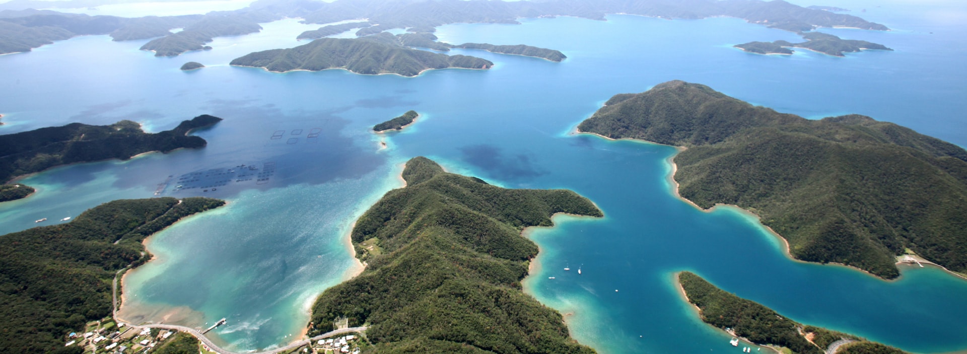
High Islands and Low Islands
The Amami Islands consists of “high islands” with high mountains, detached from the continent and developed into islands, and flat “low islands” made of elevated coral reefs.
Amami Oshima island and Tokunoshima island represent high islands with a vast natural forest of ever-green broad-leaved trees where many indigenous species inhabit.
In the forest in Amami Oshima island, gigantic trees such as “itajii” (Castanopsis sieboldii), oaks, and “tabunoki” (Machilus thunbergia) form rich tree crowns. Its high humidity helps many epiphytic plants grow. Also, clean and nutrient-rich rivers flown from the forest grow, in the process of developing a mangrove forest in the river mouth, numerous indigenous flora and fauna, forming a distinctive nature among Amami islands.
Kikaijima, Okinoerabujima, and Yoronjima islands are, on the other hand, low islands made of elevated coral reefs. Made of coral reefs, the lime stone, emerged to form the ground due to sea- level fluctuations, constitutes the foundation of these flat islands. The lime stone gradually dissolves, in the long period of time, to form sinkholes (aka dolines), limestone caves, and underground rivers (Kuragou) in these islands.
Amami Archipelago Nature and the World Natural Heritage
Since the Amami archipelago is surrounded by the Kuroshio current, the average annual temperature is about 21C°(69.8F°) with a 24C°(75.2F°) water temperature in a warm, subtropical marine climate. Seasonal winds give rise to an annual rainfall of about 3,000 milliliters suitable for the survival of species isolated from the continent in the islands in a warm, humid climate to evolve uniquely. On the high-altitude mountainous islands of Amami Oshima and Tokunoshima in particular some of the rarest endemic species in the world survive in large numbers.
Valuing such high biodiversity, Amami Oshima and Tokunoshima were registered to the World Natural Heritage along with Northern Okinawa Prefecture and Iriomotejima in July 2021.
Captions / HORIZON Editorial Office